

Fires Bring Benefits to Wildlife
F ire has been a conservation and habitat management tool as long as there have been land managers in Texas. However, sometimes blazes get out of hand—especially when it comes to natural wildfires—and there can be significant lasting impact.
One fire and its effects that state biologists continue to monitor is the historic fire in March 2008 that consumed about 95 percent of the Chaparral Wildlife Management Area. In all, the fast-moving blaze torched roughly 50,000 acres of South Texas habitat in the area, including portions of some of the state’s most celebrated trophy whitetail ranches.
It should be noted that at the time, TPWD biologists documented only about a few dozen dead animals as a result of the blaze. That massive burn has become an intriguing case study in the effect of large-scale fire on native habitats and wildlife, said Stephen Lange, area manager for “The Chap.”
“(In hindsight) that may have been the best thing that ever happened to the property,” Lange said. “In reality, it burned about two-thirds completely to the ground, but what happened was that everything we had as regrowth and re-sprout was at deer level. And it was at deer level for about the first five or six years since the fire. Then we subsequently went into our highest consecutive year of fawn production and productivity that we’ve ever had for white-tailed deer. That led to us reaching our highest deer density since the high fence was put up back in 1983.
“Because of that, we had such high numbers of deer and literally needed to shoot back the deer figures for management objectives. We had a pretty intensive public hunting program this year to get our numbers back down. We had been at a three-year average of about 17 or 18 acres per deer, so we used our harvest goals to get back to 25 acres per deer. By doing that, we’re able to go back into a drought cycle in better shape and be in a better place to maintain the range.”
Lange noted that hunters took the most deer ever on the WMA during this past season, surpassing 200 animals (130 does and 86 bucks).
“All the deer that we shoot from this point forward will be deer that were raised on this range in post-fire conditions, so that’s much different than the deer we were carrying over pre-fire,” he said. “Even if we have an average fawn crop this next year, we’ll be able to shoot 140 animals off this property, which is actually well above the long-term figure for deer harvest.
“It had been about 90 deer per year on average. What happens is when you have too many deer on a native landscape, over time you will see a drop-off in average weight of bucks and does, and you will also see a slight reduction in antler quality. That’s simply because you have so many deer, they’re consuming more resources. We still have some big deer here. We had a 169-pound deer that came in dressed this year.”
While The Chap is known for producing quality antlers even in what are down seasons, this past season was a quandary on some levels for biologists and land managers in the wake of good range conditions, Lange noted.
“We only had one TBGA (Texas Big Game Awards) deer and that was actually shot by our Big Time Texas Hunts hunter,” he said. “On the Chaparral we have one of the Big Buck Bonanza hunts and that hunter took a buck that scored 147 and change (Boone & Crockett). Now, the previous year we had a great year. We were coming off an 80 percent fawn crop from 2010 and those were our older bucks. We had a 173, a 160, a 157…five deer total that qualified for the TBGA.
“We were scratching our heads over that much of a falloff this year, but it’s because we didn’t have the fawns coming up in age. Even this coming season we won’t, but you look to 2018, 2019 and 2020 after the good fawn crops of 2013-15.
“Those should be bumper years, an opportunity to truly have some “Booner”-level deer. They’ll have the age and they’ll have the food, which is the whole reason we wanted to shoot back our deer densities.”
—BY Will Leschper
[info_box title=”” image=”” animate=””]
[heading tag=”h2″ align=”center” color=”#ffffff” style=”lines” color2=”#ffffff”]Models Help Save Mottled Ducks[/heading]
When Ducks Unlimited talks about the science underlying our conservation efforts, that’s frequently all that is said—that it’s there.
However, that science is not something to be taken for granted, and the effort and time it takes to produce useable information for guiding conservation programs should be appreciated. Here is one example of the complex path from question to answers.
The mottled duck (Anas fulvigula) is a year-round resident of coastal marshes and prairies in the Western Gulf of Mexico Coast (WGC). Population surveys indicate the WGC mottled duck population has experienced a long-term, steep decline in Texas, is stable or slightly increasing in Louisiana and is stable to declining across the entire WGC range.
Declining population trends in portions of its range have made the mottled duck a species of concern among state and federal agencies. Because the loss and degradation of nesting and brood-rearing habitats are believed to be largely responsible for historical declines, conservation and management of habitats for mottled ducks is a priority concern for area conservation partners.
But do we know where the best habitats for mottled ducks are and where to focus our conservation efforts? To answer these questions, Ducks Unlimited collaborated with other Gulf Coast conservation partners, including Texas A&M University—Kingsville, the Gulf Coast Prairie Landscape Conservation Cooperative, and the Gulf Coast Joint Venture (GCJV).
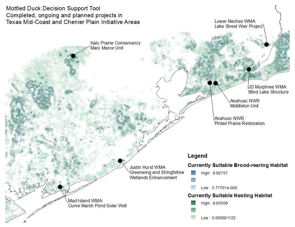
Working together, the partnership developed a Decision Support Tool (DST) to help target wetland and grassland conservation efforts to benefit nesting and brood-rearing mottled ducks.
Decision Support Tools are computer-based or graphical systems that aid stakeholders in making efficient and effective decisions. In wildlife conservation, DSTs are used to consolidate available biological and ecological knowledge within a spatial framework to identify areas on the landscape where conservation actions are expected to have the greatest benefit.
Three output models, or maps, were developed to identify good existing habitat and areas that could benefit most from habitat restoration and enhancement. Each map identifies areas on the Gulf Coast where specific conservation or management activities would be beneficial and ranks them based on their expected relative benefit, or priority. One map depicts priority areas for grassland establishment (nesting habitat). One map depicts priority areas for wetland enhancement (brood-rearing habitat). These two maps are used to target restoration and enhancement activities. The final map depicts and prioritizes areas that currently provide mottled duck habitat. This map can be used to target acquisitions, easements or maintenance activities to protect and maintain existing habitat.
Project partners tested the accuracy of the maps produced from the DST using seven years of mottled duck breeding population survey data. Preliminary results indicate that mottled ducks consistently choose landscapes identified as higher priority nesting habitat by the DST than landscapes around randomly generated points. This means the models work and provide a biologically based framework to guide habitat conservation for mottled ducks throughout the western Gulf Coast.
Ducks Unlimited uses the DST models to support proposals for public funding. By following the rigorous science of the DST, we can focus our conservation efforts where they matter most to mottled ducks. The ability to support funding proposals with information derived from DST outputs adds credibility to the proposed efforts and assures potential funders that our conservation programs are truly guided by science and planning.
Once the model was validated, conservation partners on the GCJV brought up their desire to link conservation expenditures with the model—to put their money where the science says will provide the most benefit.
As part of our agreement with the Texas Parks and Wildlife Department, Ducks Unlimited ensures that at least $100,000 of the funding they provide for the Texas Prairie Wetlands Project goes into habitats identified as high priority by the DST. Much of our conservation work along the Gulf Coast contributes to the habitat and population goals of the North American Waterfowl Management Plan through the GCJV Chenier Plain Initiative Plan and GCJV Mottled Duck Conservation Plan.
“It’s great to see an effort like this where we all, as a partnership, identified the need, took it to fruition, tested the output and are applying it on the ground. We took it all the way from planning to implementation through adaptive management,” said Cynthia Edwards, Southeast Conservation Adaptation Strategy (SECAS) Coordinator.
Even partnerships that don’t focus on mottled ducks have recognized the importance of a broad partnership identifying a science need, putting the science together and putting it into application.
—BY Andi Cooper
[/info_box]
[button title=”Return to CONTENTS Page” link=”https://fishgame.com/1706-June-issue/” target=”” align=”” icon=”” icon_position=”” color=”” font_color=”” size=”2″ full_width=”” class=”” download=”” rel=”” onclick=””]