
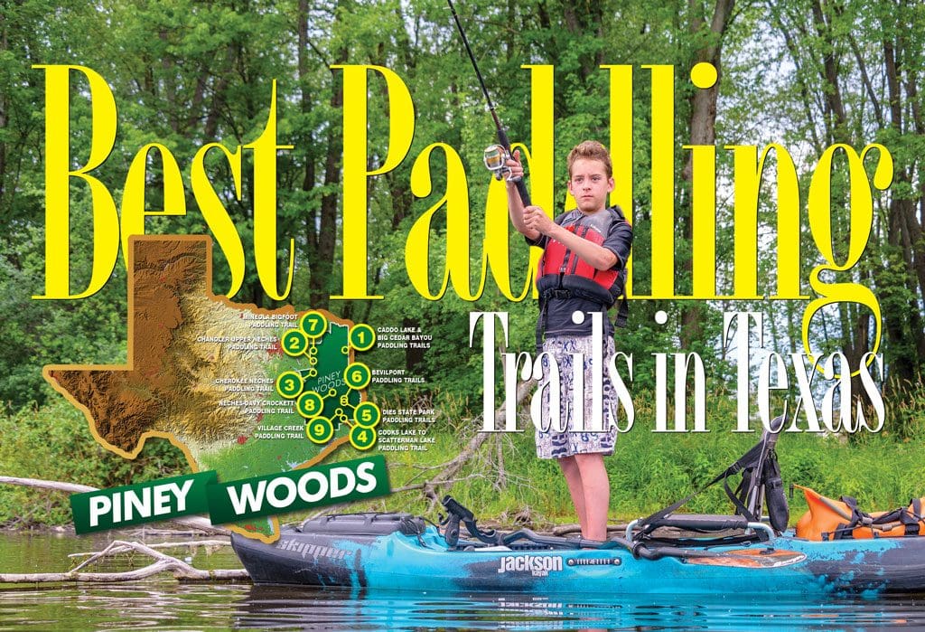
KAYAKERS HAVE HUGE opportunities in East Texas. Numerous lakes and streams feature designated paddling trails for your fishing and wildlife viewing enjoyment. If you live in East Texas and have considered getting a kayak, now is a good time. There has never been more opportunity.
Caddo Lake & Big Cedar Bayou
(Near Jefferson, Karnack and Uncertain)
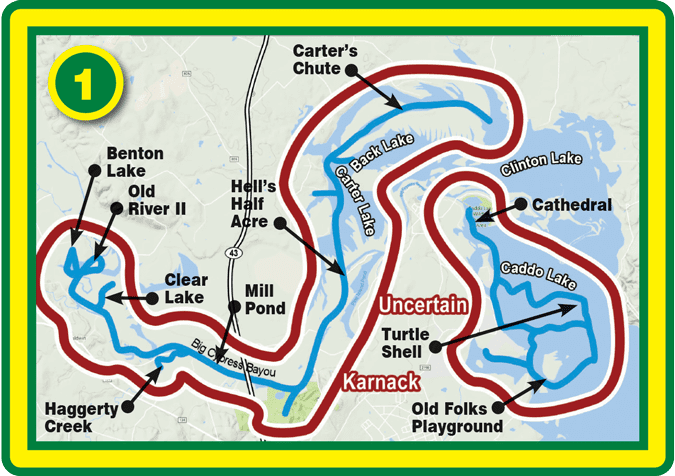
With ten official paddling trails in the region, the Caddo area now has more than 50 miles of canoe and kayak trails for visiting paddlers. Follow the trail markers posted along each of the trails to explore the mysterious maze of sloughs, swamps and bayous for which this beautiful region is known.
• Benton Lake Paddling Trail (Big Cypress Bayou)
• Clear Lake Paddling Trail (Big Cypress Bayou)
• Haggerty Creek Paddling Trail (Big Cypress Bayou)
• Mill Pond Paddling Trail (Big Cypress Bayou)
• Old River II Paddling Trail (Big Cypress Bayou)
• Carter’s Chute Paddling Trail (Caddo Lake)
• Cathedral Paddling Trail (Caddo)
• Hell’s Half Acre Paddling Trail (Caddo)
• Old Folks Playground Paddling Trail (Caddo)
• Turtle Shell Paddling Trail (Caddo)
Chandler Upper Neches Paddling Trail (Athens/Tyler)
Enjoy 1-9 miles of a great loop paddling trail just minutes from Tyler and Athens—no shuttle needed.
This loop trail can be completed in 1-4 hours, depending on water levels, flow rates, and turnaround point for your loop.

Cherokee Neches Paddling Trail
(near Jacksonville)
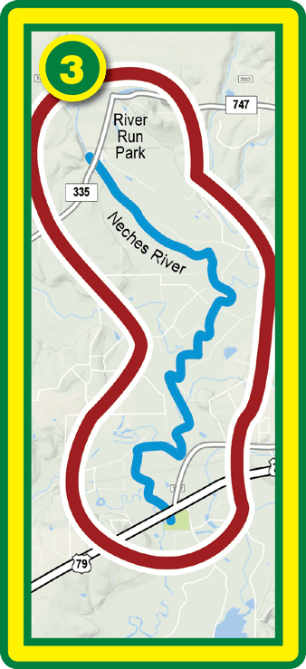
Offering 6.6 miles of paddling, this trail includes a variety of water types from quiet pools to several small riffles through the East Texas Piney Woods.
Cooks Lake to Scatterman Paddling Trail
(Beaumont)
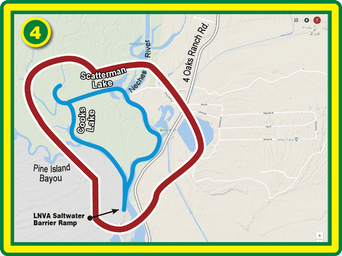
This 4.8-mile loop trail offers a great diversity of birds, wildlife, and plants as you paddle through the cypress and tupelo trees of the swamp and the river corridor of the Neches River. From the LNVA Saltwater Barrier Ramp up the Neches River, it goes up Pine Island Bayou into Cook’s Lake.
Martin Dies, Jr. State Park Paddling Trails
(near Jasper)
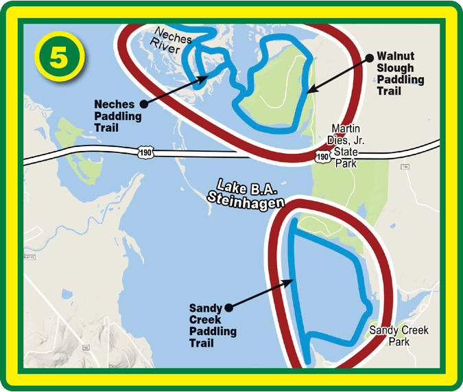
Includes the Neches Paddling Trail, Walnut Slough Paddling Trail and Sandy Creek Paddling Trail, three trails running through and around Martin Dies, Jr. State Park that offer 3 to 16 miles of paddling for a variety of experiences—from the park’s backwater sloughs and a wide open lake to a fast-moving river.
The waterways surrounding Martin Dies, Jr. State Park provide extensive habitats for a large variety of fish. The constant flow of the Angelina and Neches Rivers into Steinhagen Reservoir provides anglers with bass, crappie, perch and catfish year-round.
Bevilport Paddling Trail
(Dies State Park)
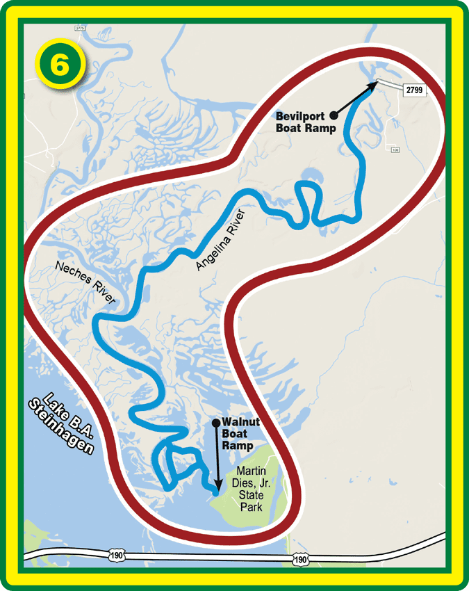
Beginning at Bevilport Boat Ramp, an historic riverboat landing site and location of the first cattle drives from Texas, this trail offers more than nine miles of river trail down the Angelina and Neches Rivers.
Mineola Bigfoot Paddling Trail
(near Mineola)
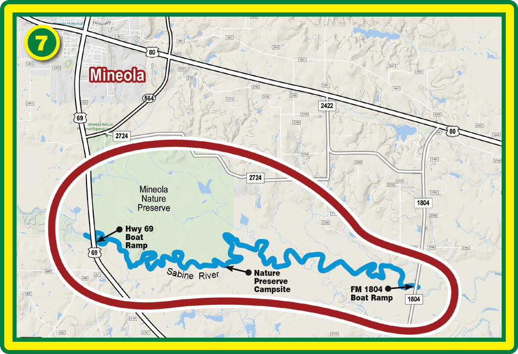
This 11.9-mile trail offers a wild and scenic view of East Texas along the beautiful Sabine River. This is a beautiful, quiet stretch of river. However, flows in the Sabine River along this stretch can be limited as they are dependent on how much water is being let out of the upstream lakes.
Five river miles into the paddling trail there is a public camp with six tables, a fire ring/grill and gravel tent sites.
This section of the river supports numerous catfish, buffalo, gar, and sunfish.
Neches-Davy Crockett Paddling Trail
(near Lufkin)
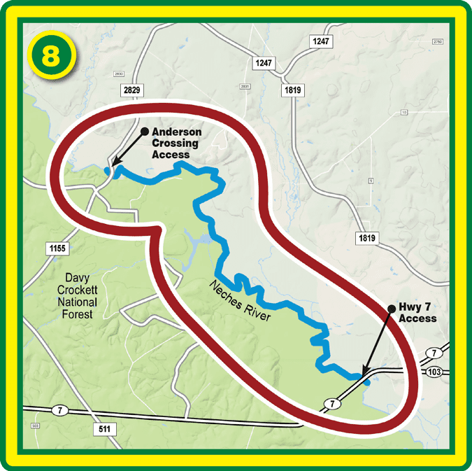
At 9.2 miles in length, this leisurely paddle on the Neches River just outside of Lufkin gives you a front row seat for the amazing biodiversity of East Texas.
Once used as a main food source for early settlers, the Neches River is still home to the native species of freshwater fish in East Texas. The mainstay of this historic fishery is catfishing. Neches River bass are smaller but much more fun to catch than their lake counterparts.
Village Creek Paddling Trail
(near Lumberton, Silsbee and Kountze)
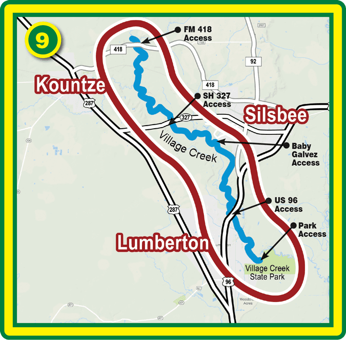
With white sandy beaches, diverse wildlife and towering pineywoods trees, this 21-mile trail with multiple access sites allows for a beautiful one-hour trip, half day paddle or even overnight camping on the river.
The entire trail is too long to paddle in one day. Overnight camping permits are free and available at the Big Thicket National Preserve Visitor Center.
[info_box title=”PADDLING SAFETY” image=”” animate=””]
[heading tag=”h2″ align=”center” color=”#ffffff” style=”lines” color2=”#ffffff”]Recognizing and Avoiding Hazardous River Conditions[/heading]
CONDITIONS ON RIVERS can change rapidly in Texas. Before setting out, a paddler should know the flow condition of the reach they are about to paddle. During high flows, the whole river reach may act like one long set of rapids. During high flows, the fast current may draw the unsuspecting paddler into other hazards. These include entrapment in floating debris such as logs, sweepers and strainers.
A sweeper is an overhanging branch or tree whose branches extend into moving water from above. Running into a sweeper will push a canoe over or could push and hold the paddler below the surface of the water. A strainer is a submerged tree or branches under the surface of moving water. A paddler could become pinned against a strainer.
Submerged hazards, such as rocks, logs and other debris, are not easily seen in turbulent water. A collision can cause the boat to upset; the hull may be punctured, or the paddler may be injured in the collision.
Once out of the canoe, the canoeist may be overcome by the current or pinned by the canoe. A swamped canoe can weigh as much as two tons and a paddler can be crushed between a canoe and a rock.
Cold water (less that 15° C) can be lethal. During spring conditions or in late fall, the river water is cold, and if you spill you can very quickly be overcome with hypothermia. Even if the paddler reaches shore, wind chill and cold air temperatures can accelerate the dangerous drop in body temperature. Shivering is an indication of the onset of hypothermia, and victims usually become too disoriented to be responsible for their own safety.
A riverbank is often well removed from emergency services and homes where help can be obtained. The tough reality is that you may be on your own to deal with a life-threatening situation. The tough reality too is that a paddler in danger may also be putting a rescuer’s life in jeopardy.
Whenever you are on the river, it is important that you are prepared to deal with an emergency. Know where access points are along the reach of river that you are canoeing. Have a map of the reach that you are canoeing. Have a first aid kit and know basic first aid. Finally, a cellular phone in a waterproof bag may be invaluable in contacting help or emergency services.
Low head dams pose a special hazard to paddlers. In the fast waters, an upstream paddler may get too close to the crest of the dam and be swept over. A paddler may also get caught in the backwash current at the downstream side of the dam. Once in the backwash current, the paddler becomes trapped. Paddlers should use portages around these structures, and stay well clear of low head dams at any time of the year.
Boating safety awareness is not limited to the cold-water seasons. There are good solid rules that must be observed by prudent and safety conscious paddlers everywhere. Boating courses are an enjoyable way to prepare for any kind of boating.
Like the Boy Scouts advocate-be prepared. Being prepared before your trip can help avoid potential hazards or result in a positive outcome if an accident does occur. One of the most important considerations is a trip or float plan. Let someone know where you are canoeing, what your boat looks like and when you expect to return.
(From the TPWD webpage, “River Safety.” For more, click HERE.)
[/info_box]
—TF&G Staff Report
[button title=”Return to CONTENTS Page” link=”https://fishgame.com/1806-june-issue/” target=”” align=”” icon=”” icon_position=”” color=”” font_color=”” size=”2″ full_width=”” class=”” download=”” rel=”” onclick=””]