

Yeah yeah, I know. We would all much rather be out on the water fishing than sitting in front of the computer. Believe me, I’m 1000-percent with you. There’s just one thing: spending a few minutes in front of the computer prior to a fishing trip can absolutely, positively boost your chances of actually catching a fish. Here are three internet tools every angler should utilize.
- Google Earth – Results will vary depending on when the satellite shots you look at were taken and how well you can zoom in, but the bird’s eye view of Google Earth can be effectively used to spot structure and channels in relatively shallow water. Just how shallow will depend on water clarity at the time the photos were taken. But in many cases, you’ll be able to spot rip-rap, sunken trees, and other structure that’s several feet down. And if those shots were taken during a low tide, you may spot structure that’s often many feet down. You won’t see fish but you can see where fish live.
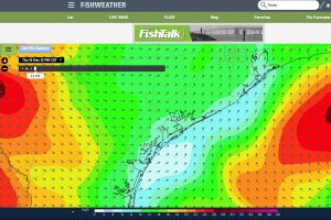
- Fishweather – Everyone has their own favorite weather source, but Fishweather is of particular interest to anglers because it’s focused on the aspects of the weather that you and I really care about. Particularly good is their wind forecast map, which gives wind speed and direction predictions up to a week in advance. That far out we don’t suggest planning around it, but a day or two prior to a trip it can be a huge help in determining what the seas will be like, or where you’ll find a fishable lee in a blow.
- NOAA Weather Buoys – Water temperature, dissolved oxygen levels, water clarity, and wave heights are a few of the details you may be able to pick up from a NOAA buoy. We say “may” because different stations gather different data, and many are somewhat limited in scope while some others collect every bit of data imaginable. We also call this one out with the caveat that sometimes these monitoring stations go down or simply read “unavailable” when you bring them up on-screen. And, of course, quite often the specific monitoring station you need most is the one that isn’t functional just when you’d like to check it out. Still, setting these problems aside, you can glean some good information from NOAA weather buoys which will help you catch more fish.