

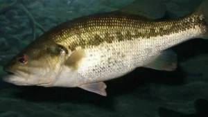
There’s a moment every bass angler knows. It’s when the pieces start to line up—the depth, the cover, the kind of bank, the way the wind is pushing. Maybe it starts with one good fish, maybe two. Then another comes from a place that looks almost the same.
That’s when you’re not just fishing anymore. You’re hunting a pattern.
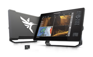
The problem is, patterns don’t last forever. They shift with light, pressure, and conditions, and if you’re not keeping up, you’re falling behind. That’s why more anglers are leaning into electronics not just to find fish, but to stay organized and move with purpose. The Humminbird XPLORE system fits right into that approach, especially for anglers who prefer to keep the trolling motor on high and cover water until they cross paths with the right fish.
Instead of committing to one area and hoping it reloads, XPLORE helps you build a clear picture of what’s happening across an entire stretch of lake. Every time you get a bite, see promising structure, or idle over something that looks right, you can mark it instantly. The system allows you to customize waypoints with different colors and icons, which may sound simple, but it becomes powerful when you start stacking information.
A brush pile that produced a solid fish might get one color. A stretch of grass that held smaller fish another. A hard spot on a point gets its own marker. By the time you’ve covered a few areas, you’re not guessing anymore—you’re seeing a pattern form in real time. Your waypoints begin to show it clearly on the screen, and that’s when decisions start getting easier.
That’s where the “stick and move” approach really comes alive.
Instead of fishing long and slow through unproductive water, you can hit a series of key spots that match what you’ve already learned. XPLORE’s cloud-based waypoint management system lets you store over 10,000 locations, which means every productive stretch, every offshore sweet spot, every overlooked edge can be logged and kept. Those waypoints sync directly to your phone through the One-Boat Network® App, so you can organize them at home, study them, or even adjust your plan before the next trip.
On the water, that translates into efficiency. You’re not wasting time trying to remember where that “one good stretch” was last month. It’s right there, clearly marked, along with dozens—or hundreds—of others that fit similar conditions.
That kind of organization changes how you fish a lake. You stop thinking in terms of spots and start thinking in terms of routes. A milk run develops naturally—one point leads to the next, then to a stretch of bank, then to an offshore piece of structure. If something doesn’t line up, you don’t force it. You move.
And when it does line up, you can lean into it hard.
Big bass tend to be loners compared to smaller fish. They set up on subtle differences—slight depth changes, isolated cover, or small sweet spots within a larger area. Those are easy to miss if you’re fishing randomly, but much easier to track when you’re marking everything and paying attention to the details.
With XPLORE, you can separate those high-quality areas from the rest. Over time, certain waypoint colors or icons start to tell a story. You begin to recognize not just where fish are, but where better fish tend to show up under certain conditions.
That’s the difference between catching bass and consistently finding the kind most anglers are after.
Texas lakes are diverse and often unforgiving. Water levels fluctuate, vegetation shifts, and fishing pressure can change things overnight. Anglers who adapt quickly tend to stay on fish, and that’s where having a system matters.
XPLORE doesn’t do the fishing for you, but it gives you a way to stay organized, keep track of what’s working, and move efficiently through a lake. It turns scattered bites into usable information and helps you build something you can run with.
In the end, it comes back to that moment when the pattern starts to reveal itself. With the right tools, you don’t just recognize it—you stay on it, expand it, and make the most of it while it lasts.
More Than Just Waypoints
While waypoint management is at the core of the XPLORE system, it’s far from the only tool in play. When you start layering in its full capabilities, the picture gets even clearer:
- Built-in Lakemaster® and CoastMaster® mapping gives you detailed contours, depth shading, and the ability to break down structure before you ever make a cast.
- SmartStrike® technology helps narrow down likely fish-holding areas based on conditions like season, time of day, and weather patterns.
- AutoChart Live lets you create your own custom maps in real time, filling in gaps and dialing in subtle structure other anglers might overlook.
- Full integration with Minn Kota® trolling motors through the One-Boat Network® allows features like Spot-Lock® and Follow-the-Contour, keeping you positioned precisely where you need to be.