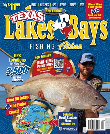
The New TEXAS LAKES & BAYS FISHING ATLAS is the latest edition of this annual book we have been publishing for 36 years.
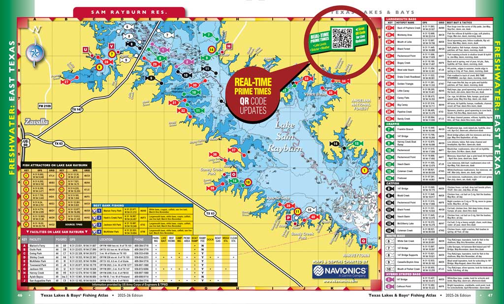
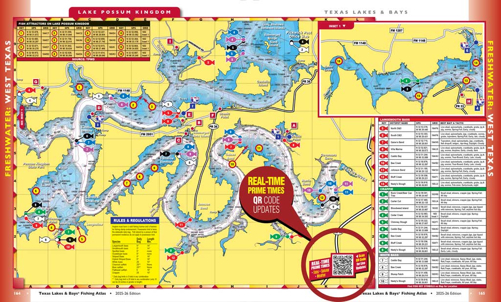
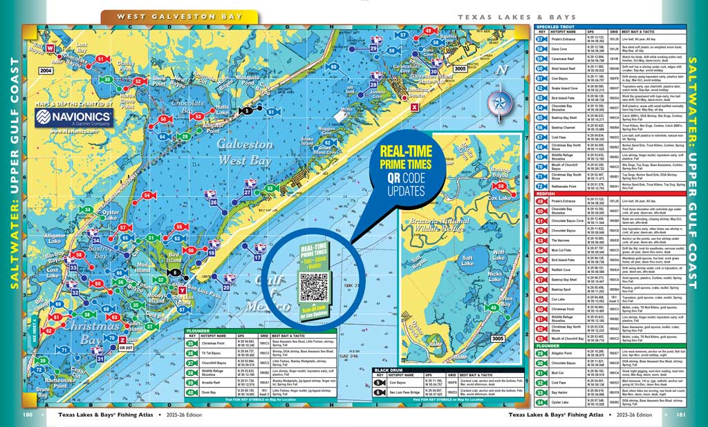
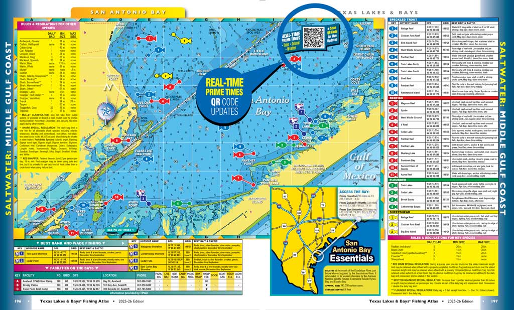
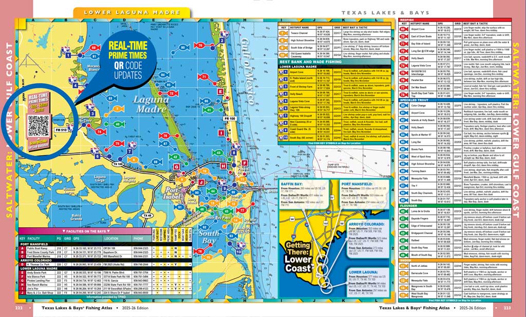
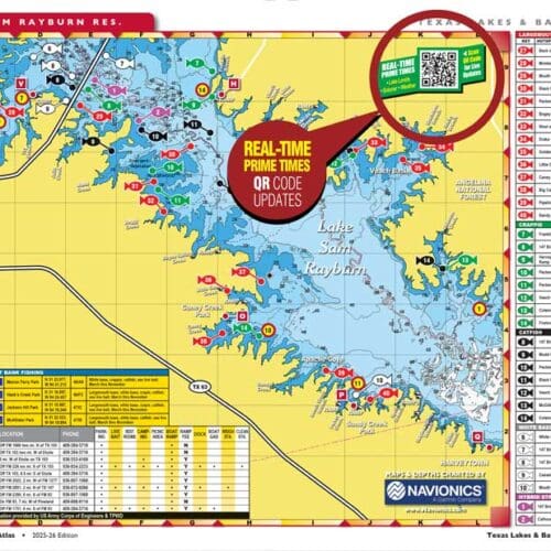
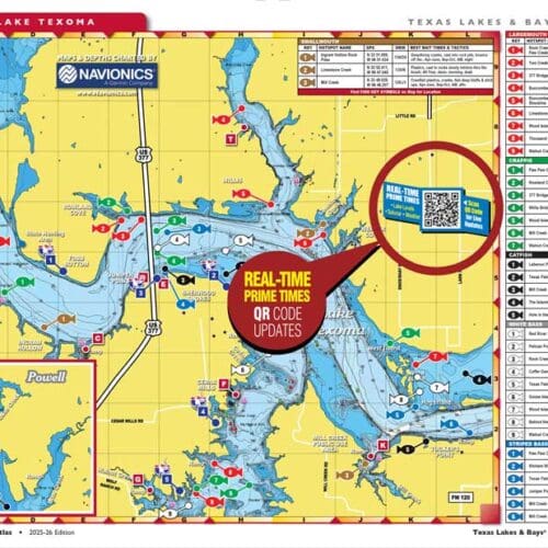
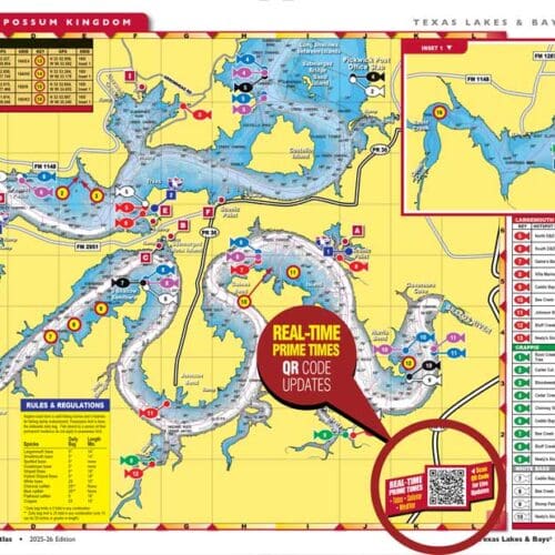
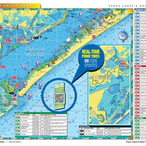
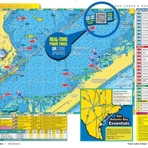
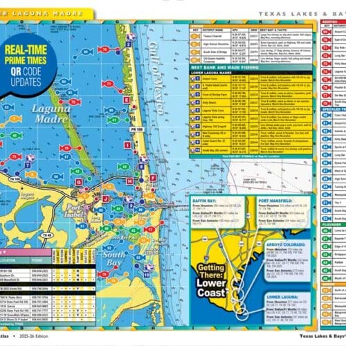
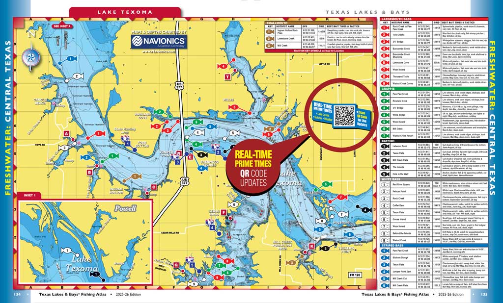
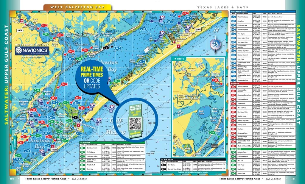
The NEW EDITION features maps and fishing spots for 56 FRESHWATER LAKES and 21 COASTAL DESTINATIONS… the entire Texas Coast, with more than 3,500 fishing hotspots. These spots include GPS coordinates and tips for fishing the spot including best time, best baits and best techniques. These tips come from fishing guides who fish the waters professionally.
QR CODE INTERACTIVITY!
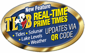
This edition features QR codes on every map that allow you to get REAL TIME PRIME TIMES, including Tides, Major and Minor “Solunar” Feeding Times and Weather for the Bays, and Major/Minor Times, Current Water Levels and Weather for the lakes.
56 FRESHWATER LAKES: 3 Regions
East Texas Featured Lakes:
Lake BA Steinhagen • Bois D’Arc Lake • Lake Bob Sandlin • Brandy Branch Res. • Caddo Lake • Chapman/Cooper Lake • Lake Conroe • Lake Fork • Lake Houston • Lake Livingston • Lake Murvaul • Lake Nacogdoches • Lake O’ the Pines • Lake Pinkston • Lake Sam Rayburn • Lake Toledo Bend • Lake Wright Patman
• • •
Central Texas Featured Lakes:
Lake Aquilla • Lake Austin • Lake Belton • Lake Benbrook • Lake Braunig • Lake Bridgeport • Lake Buchanan • Lake Calaveras • Canyon Lake • Cedar Creek Res. • Coleto Creek Res. • Lake Eagle Mountain • Fayette County Res. • Lake Granger • Lake Grapevine • Lake Joe Pool • Lake Lavon • Lake Lewisville • Lake Limestone • Lake LBJ • Lake Navarro Mills • Lake Palestine • Lake Ray Hubbard • Lake Ray Roberts • Lake Richland Chambers • Lake Somerville • Lake Stillhouse Hollow • Lake Tawakoni • Lake Texana • Lake Texoma • Lake Waco • Lake Whitney
• • •
West Texas Featured Lakes:
Lake Alan Henry • Lake Arrowhead • Lake Brownwood • Fort Phantom Hill • Lake Granbury • Lake Kemp • Lake OH Ivie • Lake Possum Kingdom
• • •
21 SALTWATER BAYS: 3 Coastal Regions
Upper Coast Featured Bays:
Sabine Lake & Pass • East Galveston Bay • Galveston/Trinity Bay • West Galveston Bay • Christmas Bay • Freeport/Cedar Lakes • East/West Matagorda Bays
• • •
Middle Coast Featured Bays:
Port O’Connor • Espiritu Santo Bay • San Antonio Bay • Mesquite Bay • Rockport/Copano Bay • Aransas Bay • Port Aransas • Corpus Christi Bay • Upper Laguna Madre
• • •
Lower Coast Featured Bays:
Baffin Bay • Middle Ground • Port Mansfield • Arroyo Colorado • Lower Laguna Madre
• • •
The maps include detailed contour depths provided by Navionics.
Every profile also includes updated information on boat ramps and facilities such as camping, docks, on-water fuel and food.
• • •
IT’S AS IF RAND MCNALLY FISHED!
We have been publishing our annual fishing atlas, aptly titled TEXAS LAKES & BAYS, since 1988. In its earliest editions, TL&B modestly presented maps and profiles of all the major bay systems down the Texas coast, plus a selection of freshwater lakes across the state.
The first couple of annual issues, just like our monthly flagship TF&G back in the early days, were printed on newsprint. As Fish & Game matured into a glossy full color magazine, Lakes & Bays grew with it. The first year we went “slick” with TL&B—the 1991 edition—we also released it on newsstands across Texas. It sold like snow cones outside a sweat lodge.
The old Lakes & Bays offered a lot of good information, and the maps—drawn by Nancy Spivey, the wife of TF&G’s founding editor Marvin Spivey—provided reference points to facilities and general locations for the best fishing. Each location was profiled in an article by one of our contributing writers who was knowledgable about the lake or bay and its unique characteristics. Basic, solid info for the travelling fisherman. An atlas for anglers.
As Lakes & Bays evolved, we tinkered with its content. We added a year-long tide forecast. We added pages, which enabled us to feature more and more lakes.
Then, in 2003, we took a significant turn. That year, we re-formatted the book. We enlarged its physical size—the “trim”—from the standard 8- x 11-inch magazine size to a larger 9 x 11. This let us enlarge all the maps. Using NOAA charts and USGS topographic maps, we built digital versions on which we could then overlay our own information.
We also added a twist that was a game changer. We recruited experienced fishing guides from each area and asked them to submit specific “hot spots” with detailed information including the species, best time of year (since this was an annual book) and the best baits and techniques for fishing each spot. The kicker was that they also gave us the GPS coordinates for each spot.
Every year, we would add new fishing spots, in addition to adding new lakes (we already had every bay). The book grew fatter and more packed with fishing holes for anglers who liked to hit the road and try lakes or bays they might not be familiar with.
In 2011, we made another significant shift—and totally overhauled the maps again. We partnered with Navionics, which enabled us to include depth contours for all the water bodies.
Last year, we implemented another complete map overhaul to make all the information fit… and happily ended up with a more functional presentation.
This edition of Texas Lakes & Bays has more than five dozen freshwater and saltwater maps, loaded with a wealth of fishing information. If you were to purchase a fishing map separately for all these locations—if they were even available for all of them—you would have to spend $600 to $800.
We have it all wrapped up for you in one easy to use package… all for just Twelve Bucks!