
NOAA-supported scientists announced that this year’s Gulf of Mexico “dead zone”— an area of low to no oxygen that can kill fish and marine life — is approximately 6,334 square miles, or equivalent to more than four million acres of habitat potentially unavailable to fish and bottom species.
The average hypoxic zone over the past five years is 5,380 square miles, which is 2.8 times larger than the 2035 target set by the Hypoxia Task Force. Since records began in 1985, the largest hypoxic zone measured was 8,776 square miles in 2017.
 measured during the ship surveys since 1985, including the target goal established by the Mississippi River/Gulf of Mexico Watershed Nutrient Task Force and the 5-year average measured size (black dashed lines). (LUMCON/NOAA)")
Scientists at Louisiana State University and the Louisiana Universities Marine Consortium led the annual dead zone survey during a research cruise from July 25 to August 1 aboard the R/V Pelican.
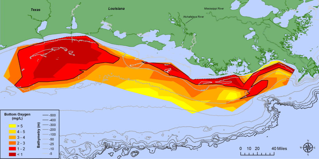
“The distribution of the low dissolved oxygen was unusual this summer,” said Nancy Rabalais, professor at Louisiana State University and LUMCON. (Louisiana University Marine Consortium) who is the principal investigator. “The area from the Mississippi River to the Atchafalaya River, which is usually larger than the area to the west of the Atchafalaya, was smaller. The area to the west of the Atchafalaya River was much larger. The low oxygen conditions were very close to shore with many observations showing an almost complete lack of oxygen.”
")
Surface waters were low in salinity across most of the study area, indicating that high freshwater runoff from the Mississippi River watershed affected the area. River discharge measured above normal for the three weeks prior to the research cruise.
The role of chief scientist was shared by Rabalais, Cassandra Glaspie, Ph.D., of LSU, and Gina Woods, LUMCON research associate. The 2021 shelf wide cruise had a full complement of scientists, which was curtailed in 2020 due to COVID restrictions.
In June, NOAA forecasted an average-sized hypoxic zone of 4,880 square miles, based primarily on the Mississippi River discharge and nutrient runoff data from the U.S. Geological Survey. With average- to below-average discharge and nutrient loading this spring, the models predicted an average hypoxic zone to form during the time of the cruise. The forecast models assume typical weather conditions and do not have capacity to factor in storms or other wind events, which can disrupt the hypoxia zone around the time of the cruise. While the model results underestimated the measured size of the zone this year, they were within the expected margin of uncertainty for the forecast and provide further evidence of the robustness of the models to relate nutrient inputs to observed hypoxia size in the summer.
Excess nutrients stimulate algae growth
Each year, excess nutrients from cities, farms and other sources in upland watersheds drain into the Gulf and stimulate algal growth during the spring and summer. The algae eventually die, sink and decompose. Throughout this process, oxygen-consuming bacteria decay the algae. The resulting low oxygen levels near the bottom are insufficient to support most marine life, rendering the habitat unusable and forcing species to move to other areas to survive. Exposure to hypoxic waters has been found to alter fish diets, growth rates, habitat use, and availability of commercially harvested species like offsite link shrimp.
“NOAA and its partners use data from this cruise to help refine models and more accurately simulate how river discharge, nutrient loads, and oceanographic conditions influence hypoxic conditions in the Gulf and affect living resources,” said Nicole LeBoeuf, Assistant Administrator for NOAA’s National Ocean Service. “By understanding the scale and effects of these hypoxia events, we can better inform the best strategies to reduce its size and minimize impacts to our coastal resources and economy.”
")
Working together
The annual hypoxic zone size determination is a key metric used by the Mississippi River/Gulf of Mexico Watershed Nutrient Task Force to measure progress toward achieving the five-year average target of 1,900-square-miles or smaller by 2035. As the survey cruise is only a snapshot of the hypoxic zone, calculating a five-year average captures the true dynamic nature of the zone more than a single annual measurement.
“This year, we have seen again and again the profound effect that climate change has on our communities — from historic drought in the west to flooding events. Climate is directly linked to water, including the flow of nutrient pollution into the Gulf of Mexico,” said EPA Assistant Administrator for Water Radhika Fox. “As we work to address the Gulf of Mexico hypoxic zone, we must consider climate change and we must strengthen our collaboration and partnerships to make needed progress.”
The Hypoxia Task Force is accelerating progress in reducing excess nutrients in the Mississippi/Atchafalaya River Basin by promoting collaboration among federal partners, states, farmers and other stakeholders. Federal agencies are supporting efforts to reduce excess nutrients, including by making $17.5 million available in 2020 to support conservation investments by agriculture producers through the U.S. Department of Agriculture’s Mississippi River Basin Healthy Watersheds Initiative. USDA is also providing more than $38 million to support producers in 300 small watersheds across the nation, including many watersheds in the Mississippi River Basin.
Additionally, initiatives such as NOAA’s Runoff Risk Forecast, designed to help farmers apply fertilizer at optimum times to ensure it stays on fields, are reaching more states and help limit nutrient runoff to the Gulf. The Hypoxia Task Force also empowers state programs by sharing successful strategies, as well as providing funding to states to support program development and implementation efforts that are tailored to finding local solutions.
“Each of the Hypoxia Task Force states are committed to showing continuous improvement towards the goals outlined in our state-level Nutrient Reduction Strategies. We have technical experts who are working alongside public and private partners, farmers and landowners, and municipalities to implement locally-led water quality projects,” said Mike Naig, Iowa’s Secretary of Agriculture and co-chair of the Hypoxia Task Force. “We know that changes on the land lead to positive changes in the water, and these investments benefit our local communities and our neighbors downstream. We are grateful to EPA and our other federal and private partners who provide support for these community-led projects. This funding allows us to scale-up our work in priority watersheds across the Mississippi River basin.”
NOAA continues to fund monitoring and research efforts to understand the dead zone as well as to study the impacts of hypoxia on fish and fisheries in the Gulf of Mexico through its Northern Gulf of Mexico Ecosystems and Hypoxia Assessment program, known as NGOMEX. LUMCON’s Gulf Hypoxia website has additional graphics and information about this summer’s research mission as well as missions in previous years.
SOURCE: NOAA
This information is not correct!!!
I fish offshore dozens of times a year and I take advantage of the short runs during snapper season and I can verify there is more than an adequate supply of marine life within 30 miles of Galveston. Snapper are found at the lower middle and upper water columns well within the red area you describe on this map.
Obviously Agenda Driven Data
I fish offshore many times a year. Snapper fishing has been very good this year as well as other species. I fish 10 to 60 miles out from Matagorda. Not sure of the accuracy of this article.