
A new U.S. Geological Survey coastal change forecast predicts sandy beaches along the northern Gulf Coast are likely to see extreme impacts from Hurricane Ida although surveys post-storm have yet to be completed.
Waves and surge caused by Hurricane Ida are likely to cause 45% of Louisiana’s and 10% of Mississippi’s sandy beaches to be inundated – meaning continuously covered by ocean water. This is the most severe type of storm effect on coastal beaches, with flooding behind the dunes that may impact coastal communities. The areas currently projected to be inundated are from Marsh Island, Louisiana, to Ship Island, Mississippi. Inundation is not expected along the Alabama and Florida coastlines.
The second most severe level of coastal damage, overwash, occurs when water levels reach higher than the top of dunes. Approximately 61% of Louisiana’s beaches and 41% of Mississippi’s beaches are expected to be overwashed by Ida. About 2% of Alabama’s beaches and 1% of beaches in Florida may also be overwashed. When a beach is overwashed, sand can be pushed and deposited inland, causing significant changes to coastal landscapes and blocking roadways. Overwash can reduce the height of protective sand dunes, alter the beaches’ profile, and leave areas behind the dunes more vulnerable to future storms.
The least severe level of storm damage on sandy shorelines is erosion at the base of sand dunes. In Louisiana, 67% of coastal dunes in Louisiana are projected to be eroded by Ida. In Mississippi, 63% of dunes will likely erode along with 31% in Alabama, and 2% in Florida.
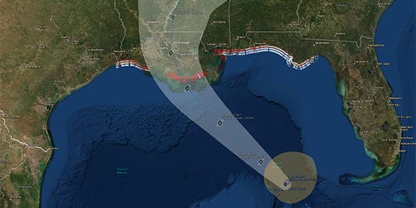
The prediction of Ida’s effects at landfall is based on results of the USGS Coastal Change Forecast model, which has been in use since 2011 and is continually being improved. The model starts with inputs from the NHC’s storm surge predictions and National Oceanic and Atmospheric Administration wave forecast models. It then adds detailed information about the expected landfall region’s beach slope and dune height. The predictions define “very likely” effects as those that have at least a 90% chance of taking place, based on the storm’s forecast track and intensity.
As the USGS continues to take all appropriate preparedness actions in response to Ida, those in the storm’s projected path can visit Ready.gov or Listo.gov for tips on creating emergency plans and putting together an emergency supply kit.